
HISTORIC PRINTS
HISTORIC PRINTS specializes in historical map and photo reproductions from throughout the world.


HISTORIC PRINTS
268 Items

FREE Delivery
Historic is guarding the constant ingenuity of historic maps in the form of vintage wall art.
FREE Delivery
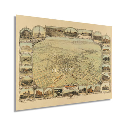
Located at the base of the southern tip of the Sierra Nevada Mountains, Bakersfield has long been a significant gateway to the Southwest. First settled by Spanish missionaries in the eighteenth century, Bakersfield would not see substantial expansion until the discovery of gold in 1851, and the discovery of oil in 1865 which attracted residents eager to extract these resources. By 1901 Bakersfield had seen a large influx of workers attracted by the increased demand for petroleum products as automobiles spurred the need for greater oil production across the United States. The city had more than triple its population in the latter portion of the late eighteenth century. Bakersfield remains a significant hub for agricultural production and energy extraction. Birds eye perspectives were widely popular during the nineteenth and twentieth centuries and bear a unique aesthetic and distinctive style that immediately transports the viewer back in time, creating an indelible bond between the past and present. Bakersfield is the County Seat of Kern County, the most productive oil-producing region in California. The city was first incorporated in 1873 and quickly grew to be one of the largest cities in California. This depiction illustrates the city in a period of significant prosperity at the turn of the twentieth century.This is an authentic piece of American cartographical history that shows the iconic city in a period of transformation as modern advances in technology gave way to traditional ways of life. The historic architecture from this period remains an enduring feature of Bakersfield’s history.Our museum quality giclee print comes printed with archival ink on premium heavyweight matte paper. This eye-catching vintage map reproduction print makes the perfect gift for anyone that loves history and imagery.

FREE Delivery
Historix is guarding the constant ingenuity of historic maps in the form of vintage wall art.
FREE Delivery
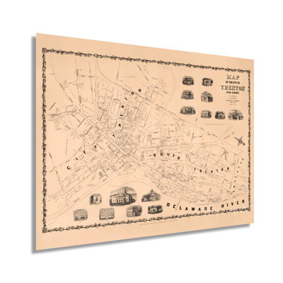
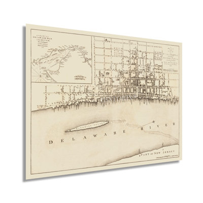
Illustrated by noted German-born lithographer and artist Augustus Kollner this unique depiction of New Jersey's State Capital and one of the earliest established cities in North America shows Trenton, NJ, in a period of significant growth and transformation. First established in 1679 as a Quaker settlement, Trenton has a rich history and deep connections to America's formation. It was the site of Washington's first victory over Hessian troops in 1776 and continued to play a pivotal role during the War of 1812 and the American Civil War. European immigrants flocked to the city during the nineteenth century, and by the middle of the 1800s, Trenton had experienced a population boom spurred on by thriving pottery and wire rope industries. These immigrants established neighborhoods and communities along cultural lines, and many still exist to this day. Though New Jersey saw no battles during the Civil War, it supplied nearly ninety-thousand troops for the Union Forces and was an essential provider of munitions and agricultural products. Trenton's direct border with Philadelphia was significant as it developed throughout the nineteenth century and became part of the greater Philadelphia municipality. Trenton's location on the Delaware River allowed for a thriving import and export industry, which further diversified Trenton's population. Kollner was based in Philadelphia and became well known for his landscapes with works in the Pennsylvania Academy of Fine Art. This rare depiction of Trenton is immediately recognizable and transports the viewer back in time, creating an indelible link between past and present.

FREE Delivery
Produced by the prolific mapmaker Rand Mcnally, this railroad and transportation map of Louisiana in 1896 depicts the state in a time of great transition as reconstruction and the turn of the century approached. The Mississippi River had long been a crucial trade route for getting goods into the midwest. The main entry at New Orleans had kept the iconic American city thriving, and the 1890s were no different. People from across the globe came through the city, and its French roots mixed with local Creole culture had developed into a distinct melting pot found nowhere else. During the Civil War, the capture of the Mississippi by Union forces marked a turning point in the war, and Union victory became apparent due to the significant importance of the river to Confederate forces. The late 20th century saw significant advances in shipbuilding, and the proliferation of locks, levees, and dams along the river started. Much of this engineering occurred to keep the river from shifting into the Atchafalaya River, thus bypassing New Orleans. The acquisition of Louisiana, as negotiated in 1803, included a vast amount of North American territory. France was engaged in multiple conflicts and needed capital to finance these clashes, allowing the new nation to acquire 828,000 sq mi of land for fifteen million dollars. The purchase would become a pivotal part of the American notion of Manifest Destiny and redefine the geography and geopolitical landscape of America. This map is truly an authentic piece of cartographical history.

FREE Delivery
Historic is guarding the constant ingenuity of historic maps in the form of vintage wall art.

FREE Delivery
Historic is guarding the constant ingenuity of historic maps in the form of vintage wall art.

FREE Delivery
Historic is guarding the constant ingenuity of historic maps in the form of vintage wall art.

2 Sizes
" Vintage 1893 Jamaica Map "
By HISTORIC PRINTS
12" H x 24" W x 0.1" D
Rated 5 out of 5 stars.2 total votes
FREE Delivery
Historic is guarding the constant ingenuity of historic maps in the form of vintage wall art.
Lawrence. Jessup, MD. Fri Oct 10 2025
FREE Delivery
Historic is guarding the constant ingenuity of historic maps in the form of vintage wall art.

FREE Delivery
Historic is guarding the constant ingenuity of historic maps in the form of vintage wall art.
FREE Delivery
FREE Delivery
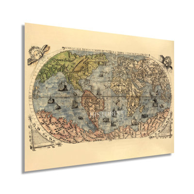
Produced and published by Venetian engraver and painter Ferrando Bertelli, this renaissance work is a genuine piece of cartographical history, and one of the earliest depictions go the entire globe. Bertelli was active for nearly five decades, and his distinctive style and unique aesthetic distinguish this work as a classic depiction from the renaissance era. This period of enlightenment, modernization, and transition was associated with significant social change throughout Europe. Bertelli’s ornate flourishes, including sailing vessels and used various colors to distinguish land and sea, were remarkable for the period and immediately transport the viewer back in time, creating an indelible bond between the past and present.This work was donated to the Library of Congress by well-known American businessman and Philanthropist Lessing J. Rosenwald in 1979 at the direction of his estate. Lessing’s private collection held thousands of rare antiquities, including maps, paintings, books, and the “Giant Bible of Mainz,” which has been on permanent display at the entrance to the Library of Congress since Rosenwald’s donation in 1951. The renaissance period is considered one of the most important for cartographic history as scientific advances, classical mapping techniques, and expanding trade routes allowed engravers greater access to geographical data combined with advances in mathematics changed the fundamental concept of the map. As maps became more accurate, explorers were able to travel further and discover new regions. Advances in printing techniques also allowed greater access to physical maps, spurring their production and distribution across Europe and North America. Our museum quality giclee print comes printed with archival ink on premium heavyweight matte paper. This eye-catching vintage map reproduction print makes the perfect gift for anyone that loves history and imagery.

FREE Delivery
In the mid-nineteenth century, American settlers moved west as part of a significant migration spurred by the expansion of settlements across Utah, Arizona, New Mexico, and California. The iconic Grand Canyon became one of the most notable geologic features encountered on this journey. It would go on to be recognized as one of the most iconic natural features in the United States. This map was published seven years after the Grand Canyon was officially declared a National Park, following efforts for preservation started by President Theodore Roosevelt in 1903. Indigenous peoples inhabited the Canyon for thousands of years before Spanish explorers discovered it in 1540.The Colorado River has carved out the Canyon over nearly two billion years. It has fascinated tourists and geologists alike with its unique features and a climate that varies drastically from the peak to the basin. During the nineteenth century, several attempts to establish mines in the area proved unsuccessful due to the rugged terrain and steep cliffs that characterize the Grand Canyon. With a depth of more than one mile and a length of nearly two hundred and eighty miles, the site attracts almost five million tourists annually. This map illustrates the vastness of the remote region of Northern Arizona that is home to the Grand Canyon. Numerous archaeological sites are found in caves and other features indicating inhabitants in the area for thousands of years prior to European contact. This map bears a classic style and immediately transports the viewer back in time.Our museum quality giclee print comes printed with archival ink on premium heavyweight matte paper.
FREE Delivery
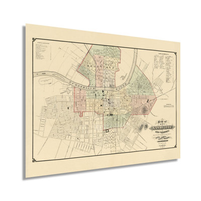
Published by the prominent and prolific WJ Morgan Lithography Company, this birds-eye perspective shows Sandusky in a period of prosperity, growth, and expansion. Located on the northern shores of Lake Erie midway between Toledo and Cleveland, Sandusky has a history that days back to the mid-eighteenth century as a trading outpost for English, French, and Americans. Sandusky was officially incorporated in 1824, and its proximity to Lake Erie allowed it to develop a flourishing economy primarily based on the movement of goods from the ports in the East. The mild climate also created a thriving winemaking and agricultural industry that exists to this day. WJ Morgan Lithography was established in 1866 and still produces maps to this day. In 1887 they became the exclusive producer of marketing materials for the Ringling Brothers Circus and won awards at Bothe the Chicago Exposition and Paris World Fair for their large-scale billboard-sized posters. They were the first company to produce posters in this style. This detailed birds-eye perspective bears a unique aesthetic and distinctive style that immediately transports the viewer back in time, creating an indelible bond between the past and present. Birdseye perspectives were used as promotional materials for cities across the nation and detailed notable civic features, buildings, and other enticing aspects to attract residents and merchants alike. They were popular from the mid-nineteenth century until the 1920s with advances in aerial photography. This stunning depiction is an authentic piece of American cartographical history.Our museum quality giclee print comes printed with archival ink on premium heavyweight matte paper.

FREE Delivery
Produced and published by one of the most well-regarded Canadian producers, the Copp Clark Company, founded in 1869 and remains in business to this day. Copp Clark published numerous maps, atlases, and birds-eye perspectives in addition to books and periodicals and was one of the largest publishing firms in Canada in the late nineteenth century. Toronto remains Canada’s largest city and has been an important cultural and economic hub for the Nation since it was incorporated in 1834. Toronto became the capital of the province of Ontario in 1867 and was the capital of Canada for two brief periods from 1849 to 1852 and 1856 to 1858. Toronto was a major destination for immigrants during the nineteenth century, with Irish Catholics becoming the largest single ethnic group by the 1850s. Their cultural influences would remain a critical part of the regional character for the remainder of the nineteenth century and the early portions of the twentieth century. By the 1860s, the city had established an extensive sanitation system, gas-powered street lamps and became the largest alcohol producer in North America. The completion of numerous railroads in the 1850s had expanded access to markets in the Midwest and Northeastern United States.This work's distinctive style and unique aesthetic immediately transport the viewer back in time, creating an indelible bond between the past and present. The latter portion of the nineteenth century saw significant growth, prosperity, and transformation for Toronto, and this is an authentic piece of the city’s cartographical history.Our museum quality giclee print comes printed with archival ink on premium heavyweight matte paper.
2 Sizes
" 1859 Bird's Eye View Of Mt Vernon The Home Of George Washington Map "
By HISTORIC PRINTS
18" H x 24" W
FREE Delivery
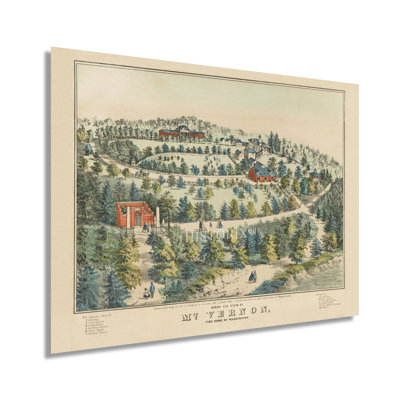
Perhaps one of the most iconic private residences in America, Mt. Vernon was the home of First President George Washington, from 1764 until his death in 1799. Located on the banks of the Potomac River near Alexandria, the estate has been visited for over two hundred years and was acquired by the Mount Vernon Ladies Association in 1858. Unlike many other similar estates throughout Virginia and much of the South, the grounds escaped any damage during the Civil War. Mount Vernon was a neutral site for Union and Confederacy troops during the Civil War, and troops left their arms behind before entering the estate.Mount Vernon was given a National Historic Landmark designation in 1960, one hundred years after its initial opening to the public, and remains owned and operated by the Association. This birds-eye perspective bears a unique aesthetic and distinctive style that immediately transports the viewer back in time, creating an indelible bond between the past and present. These depictions were among the most popular illustration of cities, towns, and notable buildings throughout the nineteenth century and would remain so until the advent of aerial photography in the 1920s.In 1878 steamboats began ferrying visitors via the Potomac, and later, the Alexandria and Mount Vernon Electric Railway offered service between the city and the estate, further expanding access. The property had been in the Washington family since 1690. This is an authentic piece of both American History and cartographical history with significant ties to America’s distinct culture.Our museum quality giclee print comes printed with archival ink on premium heavyweight matte paper.
FREE Delivery
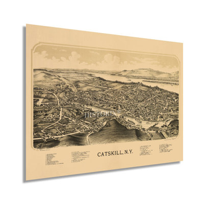
Produced by one of the most prolific map illustrators of the nineteenth century, Lucien Burleigh, this stunning depiction of Catskill bears a unique aesthetic and distinctive style that immediately transports the viewer back in time. More than one hundred and sixty of his works have been included in the Library of Congress, and his career spanned more than four decades. The birds-eye perspective was a widely popular style in the nineteenth century and was used to promote notable civic features to attract residents and merchants alike. Because these were not intended to be accurate maps for geographical purposes, the sense of scale is often distorted, giving them their signature look.First settled in 1680, Catskill was officially established in 1788 and would go on to incorporate Woodstock in 1800. Located on the banks of the iconic Hudson River, the city became a popular destination for New Yorkers looking to escape the bustle of the town during the summer months. Settlement in the region was spurred by Dutch immigrants who established numerous mills and other manufacturing plants that would thrive during the nineteenth century.The Catskill Mountains are known for their pastoral beauty, numerous rivers and lakes, and vast forests that attract visitors during the changing of the seasons. Though the town contained only ten houses at the conclusion of the American Revolution by 1889, it had grown significantly and was the county seat of Greene County. This is an authentic piece of American cartographical history by one of the most prolific illustrators.Our museum quality giclee print comes printed with archival ink on premium heavyweight matte paper.

2 Sizes
" 1903 Hawaii Samoan Islands & Guam Map;1903 Hawaii Samoan Islands & Guam Map "
By HISTORIC PRINTS
18" H x 24" W
FREE Delivery
Published four years after Guam was ceded to the United States by Spain, the postal map of the Western Pacific includes the Samoan Islands and Hawaii. As global trade increased, the importance of international mail became crucial to the world economy. The United States' interest in the Western Pacific facilitated the need for the establishment of naval outposts across the vast ocean. The Samoan Islands are an archipelago comprised of nearly 1200 miles and are home to one of the largest Polynesian populations. Europeans first made contact with Samoa in the late eighteenth century, and they were dubbed the Navigator Islands and would be until the 1870s as political interest in the area increased.The area would become one of the central focuses of the American military during World War II as fighting with the Japanese increased in the Pacific Theater. The entire region has been critical to global trade for centuries and bears distinct cultures that retain traditional values and norms influenced by Western culture. British explorer James Cook was the first European to make contact with native Hawaiians in 1778. Hawaii was made an official State in 1959 and is the most recent to join the Union. This map's distinct aesthetic and technical expertise is particularly notable given the vastness of the region and the difficulty of charting and mapping such a large area. This is an authentic piece of cartographical history with increased significance given its particular creation demonstrating international postal routes as the global economy grew and expanded.Our museum quality giclee print comes printed with archival ink on premium heavyweight matte paper.
FREE Delivery
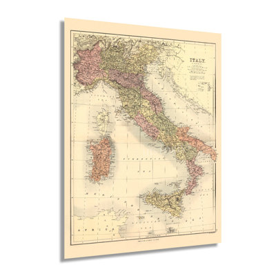
Published by the iconic Charles Scribners Sons, a New York-based firm that was founded in 1846, this distinctive illustration of Italy in the late nineteenth century stands as a unique piece of American and Italian cartographical history. The iconic publishing house would expand during its history and would produce some of the greatest American literary works of the twentieth century. Due to its geographic location and proximity to the Mediterranean, Italy has been home to a wide range of cultures, peoples, and governing bodies. By the first century BC, the Roman Empire had become the dominant political and cultural center for the entire Mediterranean Basin and would remain the dominant power for the next two hundred years. The Early Middle Ages saw the fall of the Roman Empire as Europe entered a period of migration and a blending of numerous cultures. By the eleventh century, Rome had re-entered a period of significant prosperity and marked the beginning of the Renaissance. This cultural revolution began in Italy but spread across Europe, producing some of the most influential works in art, literature, philosophy, and music.By the time of this map’s publication, numerous Italian-American communities had been established for decades in New York City and endure to this day. Rapid industrialization in Northern Italy during the latter portions of the nineteenth century had spurred economic growth. However, this would slow following the conclusion of World War I, ultimately leading to the establishment of a Fascist Government in 1922.Our museum quality giclee print comes printed with archival ink on premium heavyweight matte paper.
FREE Delivery
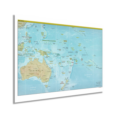
Comprised of an extensive array of islands, archipelagoes, and Australia, Oceania is a culturally, geographically, and biologically diverse region marked by distinct cultures developed over centuries of oceanic exploration and the eventual colonization of Australia by the British. Europeans first explored the area in the sixteenth century with Portuguese expeditions that reached the Tanimbar Islands west of Papua New Guinea. Captain James Cook would conduct more extensive expeditions throughout Oceania during the eighteenth century and is credited with being the first European Hawaii. The region has a unique blend of economies from major markets in Australia to society that remain largely agrarian and less modern. Further development would occur throughout the twentieth century as the Pacific Theater of World War II caused the extensive establishment of US Naval, Air Force, and Army bases in strategic points across Indonesia and smaller islands that aimed to defeat Japanese forces. Polynesians were granted French citizenship in 1946 following the conclusion of the war and changed the island's status to overseas territory of French Polynesia. The Pacific Islands Forum spawned from the South Pacific Forum in 2000 and represented the political interests of the smaller island nations on a global level. The Central Intelligence Agency began producing geopolitical maps in 1941, and these depictions are considered the most accurate representations. Political and military leaders utilize them to develop policy and strategy. This is an immediately recognizable piece of modern cartographical history that illustrates one of the most unique regions on the planet.Our museum quality giclee print comes printed with archival ink on premium heavyweight matte paper.
FREE Delivery
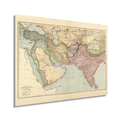
Produced and published by the prominent English mapmaking company founded by Royal Geographical Society member Edward Stanford, this intricately detailed depiction of the regions between Constantinople and Calcutta immediately transports the viewer back in time. Stanford's career spanned more than six decades, and the Stanford shop has become an iconic London landmark. Stanford's work across Asia, India, and the Middle East are among some of these regions' most sought-after productions. His extensive travel and maps were colloquially known as Library Maps. He worked closely with explorers, and the Stanford Range in British Columbia bears his namesake. The early twentieth century was a period of significant transition as advances in the western world expanded access, and the modern era was rushing forward. Published only two years before World War I, these regions would see significant expansion and development throughout the coming decades. Constantinople was the Roman Capital of the Middle East until it was renamed Istanbul in 1930. Calcutta remains the Capital of the western Indian state of West Bengal and was the center for the Indian independence movement, which gained control of the nation from British colonial rule in 1947. This map's distinctive aesthetic and classic appearance make it an authentic piece of global and cartographical history. Stanford's pedigree and skill made him one of the most respected English cartographers of the nineteenth century. As British expansion increased during the eighteenth and nineteenth centuries, maps became extremely popular, and Stanford was the first sole proprietor.Our museum quality giclee print comes printed with archival ink on premium heavyweight matte paper.
FREE Delivery
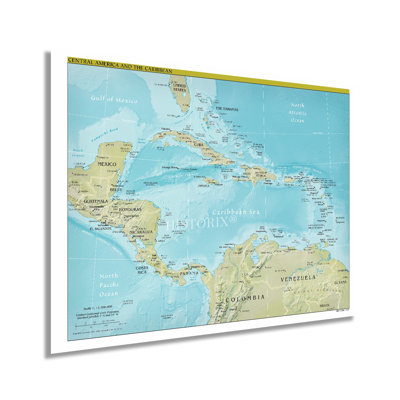
Published in a period of relative stability for Central America, this Central Intelligence Agency production depicts the geopolitical boundaries and distinct cultures that distinguish the region from its neighbors, the North and South. The region has long been under European colonial rule. Many nations achieved independence in the nineteenth and twentieth centuries, leading to a period of instability and social unrest due to varying economic factors. The distinct blend of indigenous language, traditions, and beliefs has been imbued with European influences since the discovery of North America by European settlers in 1492. Santa Domingo in modern-day Dominican Republic was the first European settlement in 1493 and remains the longest inhabited European settlement in Central America.Spain began to colonize the Americas further in 1609 and established numerous Catholic Churches throughout the region, which would become the predominant religion for the subsequent centuries. As part of the Mesoamerican biodiversity hotspot, Central America is home to a wide range of flora and fauna and contains some of the most active fault lines on the planet. Bordered by the Pacific Ocean to the west and the Caribbean to the East, the coastal regions of Central America stand in stark contrast to the interior geography, which is marked by tropical rainforests and mountainous features.CIA maps are regarded as the most accurate geopolitical depictions and are used by political and military leaders to develop and implement policy and strategy. During the early twenty-first century, Central America became an emerging market with relative political stability.Our museum quality giclee print comes printed with archival ink on premium heavyweight matte paper.
FREE Delivery
Published during a period of rebuilding and growth, Tennessee’s State Capital of Nashville has a rich history, unique culture, and this depiction offers a window into its development and evolution. In the decade following the conclusion of the Civil War, Nashville experienced a population boom as a robust local economy expanded due to increased manufacturing jobs, a busy inland port on the Cumberland River, and the number of residents grew exponentially in the latter parts of the nineteenth century. The city had been the site of a bloody clash between Union and Confederate forces in 1862 and was controlled by the Union until the end of the war in 1865. Another significant Confederate loss occurred in 1864 with the defeat of Confederate General Hood in what would become a turning point in the conflict.Compiled by Massachusetts-born Wilbur F. Fisk, who had relocated to the city in 1851 at the age of seventeen to begin his career as a surveyor and cartographer. Nashville was charted in 1806 and became a political, commercial, and financial center of Tennessee, given its central location and proximity to a major waterway. Nashville became the permanent State Capital in 1843, with the capital building being completed in 1859. Citizens throughout the south flocked to Nashville both during the Civil War and in the decades following as jobs were plentiful and it was safer than the surrounding countryside. The distinctive aesthetic and minimal style immediately transports the viewer back in time, creating an indelible bond.Our museum quality giclee print comes printed with archival ink on premium heavyweight matte paper.
2 Sizes
" 1904 Cuba Map Print "
By HISTORIC PRINTS
24" H x 36" W
Rated 5 out of 5 stars.1 total vote
FREE Delivery
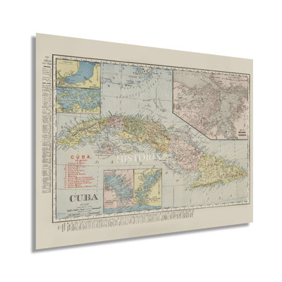
In the late nineteenth century, widespread investment by foreign companies spurred economic growth and prosperity throughout Cuba, and it was flourishing and experiencing significant growth in the early twentieth century. Following the conclusion of the Spanish-American War, Cuba became a protectorate of the United States under provisions included in the Treaty of Paris, which was signed in 1898. Cuba’s new constitution allowed the US to intervene in international affairs, financial policies, and diplomatic relationships. Cuba also agreed to lease the US land for the Naval base at Guantanamo Bay. This period also saw economic expansion spurred by a thriving sugar cane industry and the establishment of rail lines during the nineteenth century.Produced by the iconic American mapmakers Rand McNally, this detailed map is immediately recognizable. It presents the iconic Caribbean Island with remarkable detail and attention to the distinct provinces, towns, and cities. Foreign interest, particularly by American industrialists, remained high throughout the twentieth century until the Castro revolution took political control in 1959. This depiction was initially published in the McNally business atlas of Cuba and later reproduced as an independent print. With a population of more than one and a half million, Cuba was enjoying this period of prosperity and growth as a cultural center of the region, and Havana became known as Paris of the Antilles. This is an authentic piece of cartographical history that bears a distinctive style and classic aesthetic that provides the viewer an indelible link to the past and present.Our museum quality giclee print comes printed with archival ink on premium heavyweight matte paper.
It’s for the map lover and pre-Castro history buff. It has all the provinces identified as they existed in the 1950’s as well as the rail lines. Pretty cool. It was for my home office Cuba wall which is not quite finished but I love it. Makes me feel connected to my roots.. Kira. Califon, NJ. Mon Jul 01 2024

2 Sizes
" 1893 Flat Earth Map Of The World;1893 Flat Earth Map Of The World "
By HISTORIC PRINTS
18" H x 24" W
Rated 5 out of 5 stars.1 total vote
FREE Delivery
Based on a literal interpretation of the Bible, this map depicts the earth's continents in a donut-like basin and portends a flat earth theory that discounts the existence of gravity. Produced and published by self-proclaimed doctor Orlando Ferguson, a native of South Dakota, this map existed in relative obscurity until it was donated and accepted by the Library of Congress in 2011. His depiction places the sun and moon in lamp-like positions and attempts to explain the so-called Columbus phenomenon. This is the perception of a ship breaching the horizon with only the mast being visible before the hull comes into view, and the view of the ship grows as it gets nearer.When the Library of Congress received the map, it was one of only two known to exist still and the only intact representation. This rare piece of cartographical history shows the world in a period of significant advances in technology and culture. As the nineteenth century neared, industrialization and improvements in transportation had caused a boom of prosperity throughout Northern America during the Gilded Age. As the turn of the century neared, the world was transitioning from traditional agrarian cultures to a more urban, developed, and modern setting. The unique aesthetic and distinctive style of this piece immediately transport the viewer back in time, creating an indelible bond between the past and present. This original work of cartographical history has become an important artifact documenting alternative scientific theories and thinking.Our museum quality giclee print comes printed with archival ink on premium heavyweight matte paper.
Marlena. Mount Juliet, TN. Thu Jan 22 2026

FREE Delivery
Throughout most of the nineteenth century, Newport News was a small fishing village that experienced rapid growth in the 1880s following the construction of the Newport News Shipbuilding and Drydock Company. This new industry attracted many residents in the years following the conclusion of the Civil War. The factory was founded by wealthy California railroad magnate Collis P. Huntington who had been recruited to complete the Chesapeake and Ohio Railway in the 1870s. The city’s downtown area was incorporated as an independent city in 1896 and remains a historic part of the region with iconic architecture and a traditional aesthetic.This stunning birds-eye perspective shows the city in a period of significant transformation economically, politically, and culturally. Located at the southern end of the Virginia Peninsula, the city served as an essential hub for transporting imports to inland States and exporting valuable crops and coal to major markets in the Northeast and abroad. Birds eye perspectives were a widely popular style of map that served as marketing materials to attract residents and merchants alike and featured prominent civic features and economic opportunities. Newport News was one of the original eight shires of the Virginia colony as decreed by king Edward in 1634. This map was published during one of the most significant periods of expansion for the city, and this illustration immediately transports the viewer back in time, creating an indelible bond between the past and present. This is an authentic piece of American cartographical history with a distinguished aesthetic.Our museum quality giclee print comes printed with archival ink on premium heavyweight matte paper. This eye-catching vintage map reproduction print makes the perfect gift for anyone that loves history and imagery.
FREE Delivery
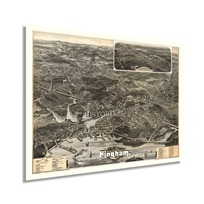
Located on the Boston Harbor some nineteen miles south of the center of Boston, Hingham's rich colonial history and significance as part of the greater metropolitan area remain part of the iconic region that's emblematic of the earliest English settlers of the United States. Produced and published by George H. Walker & Co., this map bears a distinctive style that is immediately recognizable. His company produced numerous works of towns and cities across the Northeast and bear a signature aesthetic. Walker's legacy would become a part of American history itself, with his grandson, and great-grandson going on to become the 41st and 43rd American Presidents, respectively.Birds eye perspectives were widely popular during the mid-nineteenth century and early portions of the twentieth century and transport the viewer back in time, creating an indelible bond between the past and present. Hingham was first settled by English immigrants in 1633 and became an essential part of the greater Boston area throughout America's colonial years. By 1885 the city enjoyed a significant period of prosperity as the nation neared the turn of the century. Hingham bears classic architecture and maintains a rich history with links to the most formative years of the nation.This is an authentic piece of American cartographical history that captures Hingham's rich history as the United States transformed in a period of significant technological advances and prosperity as the turn of the century approached. As the Boston area grew, its culture became one of the most iconic in the United States. Our museum quality giclee print comes printed with archival ink on premium heavyweight matte paper. This eye-catching vintage map reproduction print makes the perfect gift for anyone that loves history and imagery.
FREE Delivery
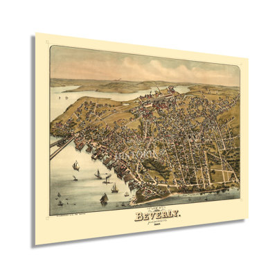
Known as the birthplace of the American Industrial Revolution, Beverly, Massachusetts, remains an iconic suburb of Boston. Additionally, it was the site of the first cotton mill in America in 1787 and by the later portions of the nineteenth century had become a popular destination for residents looking to get out of Boston during the summer. This stunning depiction shows the city in a period of significant growth and transformation, though it would not be incorporated until 1894. Its geographic location on the North Shore of Massachusetts has attracted residents since the earliest days of North American settlement by immigrants from England and Western Europe. The area was first inhabited by Europeans as early as 1626, and the first ship commissioned by the United States Navy sailed out of the Beverly harbor in 1775 after being outfitted in Glover’s Wharf. By the end of the nineteenth century, numerous groups of immigrants were attracted to the region. They established communities and neighborhoods based along cultural lines, many of which exist to this day. The area maintained an essential manufacturing industry throughout the nineteenth and twentieth century, which attracted residents not only from Boston to the South but across America and Europe as well.Birds eye perspectives were widely popular during this period and served as marketing materials to entice residents and merchants alike, featuring prominent civic buildings, religious, cultural, and educational institutions, as well as geography attractions and other economic opportunities. The unique aesthetic of this illustration immediately transports the viewer back in time.Our museum quality giclee print comes printed with archival ink on premium heavyweight matte paper. This eye-catching vintage map reproduction print makes the perfect gift for anyone that loves history and imagery.

FREE Delivery
Produced and published by one of the most prolific cartographers of the form, Henry Wellge, this stunning depiction of Santa Fe shows the iconic city in a period of significant transformation and growth. Wellge's distinctive style and ornate flourishes are immediately recognizable, transporting the viewer back in time creating an indelible bond between the past and present. Wellge was among a group of cartographers responsible for producing more than half of the panoramic maps of towns and cities across the United States. These unique maps were created to promote economic opportunities, prominent civic buildings, and natural attractions. Spanish explorers first settled in Santa Fe as early as the sixteenth century and would control much of the region until the United States declared war on Mexico in 1846. Following the conclusion of the Mexican-American War, the Treaty of Guadalupe-Hidalgo ceded the land to the United States, though it would remain a territory until achieving statehood in 1914. Upon becoming an official American state, Santa Fe was named the Capital of New Mexico. This map was published two years after Santa Fe was given rail access via a branch line to Lamy, New Mexico, some eighteen miles to the South.This is an authentic piece of American cartographical history that captures this jewel of the Southwest in a period of significant economic, cultural, and political transformation, and the nation neared the turn of the twentieth century. The late nineteenth century saw Santa Fe becoming a modern city and gateway to the West.Our museum quality giclee print comes printed with archival ink on premium heavyweight matte paper. This eye-catching vintage map reproduction print makes the perfect gift for anyone that loves history and imagery.
FREE Delivery
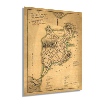
Published in the midst of the American Revolution and only one year after, Revolutionary Forces reclaimed control of Boston from the British forces who had taken control during the Siege of Boston. The Siege began following the battles of Lexington and Concord as the Continental Army started minor skirmishes in the city and began to cut off British supply lines into the city from both land and sea. Boston was the political center of the American Revolution as well as the site of the Boston Massacre in 1770, which began the calls for independence from Colonial rule. This map was published by Sir Thomas Hyde Page and is unique in that it’s a British work created during the revolution and not in the years preceding it. It also bears an inscription detailing the British retreat to Nova Scotia and the of the Battery at Fort Hill. Boston remains one of the most iconic American cities, and its role in shaping the political, cultural, and economic future of the United States cannot be underestimated. Boston is one of the oldest municipalities in the United States and was first settled in 1630. Its role as a central manufacturing hub continued following the conclusion of the American Revolution, and it has remained one of the most influential American cities for centuries.This map's distinctive aesthetic and antique style immediately transports the viewer back in time, creating an indelible bond between the past and present; this is an authentic piece of American cartographical history.Our museum quality giclee print comes printed with archival ink on premium heavyweight matte paper. This eye-catching vintage map reproduction print makes the perfect gift for anyone that loves history and imagery.

FREE Delivery
The rich details and technical analytics present in this unique depiction differentiate to from other styles of cartographical pieces. The distinctive style is immediately recognizable and informs the viewer with historical data such as average rainfall as well as high and low-temperature records. These maps define thirteen zones and are widely used for gardening, landscaping, and agricultural purposes. The United States Department of Agriculture produces these maps annually, and the first official publication was completed in 1960. Though, attempts at creating a map of these zones have been attempted since 1927. Advances in meteorological technology along with other significant developments like computers, accurate digital thermometers, and satellite imagery would cause considerable gains in the development of these pieces, which were completely revamped in 1990. This depiction was completed after another overhaul by the Arbor Day Foundation in 2006 further altered the aesthetic and performed revisions based on current data. This map was also the first update since 2006 that increased the zones by two to reflect better definitions for tropical and semitropical plants and include Hawaii and Puerto Rico. Zone boundaries were also shifted in the 2012 publication to reflect changes to regional climates and seasonality.This publication is also interesting as the zones reflected higher temperatures; a half zone warmer than the 1990 map. These unique pieces of cartographical history are among some of the lesser-known works, though they offer an interesting perspective on changing weather patterns. They are also an invaluable tool for arborists and horticulturalists.Our museum quality giclee print comes printed with archival ink on premium heavyweight matte paper. Shipped in a cardboard tube your print will arrive ready to be framed. This eye-catching vintage map reproduction print makes the perfect gift for anyone that loves history.
FREE Delivery
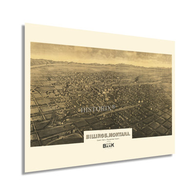
The largest city in Montana, Billings remains an enduring and iconic symbol of the American West and an essential trade hub since its founding in 1882. The city grew to more than two thousand residents in its first three months. This rapid expansion earned the city the nickname “The Magic City,” as it quickly appeared following its establishment. The discovery of oil fields in Montana and Wyoming in the early portions of the twentieth century spurred economic growth, and Billings became the financial and investment center of the remote region. Subsequent discoveries of natural gas and coal further expanded the city’s reputation as an essential energy provider and broker.Billings is the county seat of Yellowstone County, and more than two-thirds of the city is located in the Yellowstone Valley. Geographically, Billings is divided by the Rimrocks, which have helped shape the local culture and urban development. The city is surrounded by seven mountain ranges and includes views of the Absaroka Range which comprises the eastern border of Yellowstone National Park. Produced by one of the most prolific American mapmakers, Henry Wellge, this birds-eye perspective bears a distinctive aesthetic and characteristic style that immediately transports the viewer back in time. Birdseye perspectives were widely popular during the nineteenth and early twentieth century and served as marketing materials to attract residents and merchants alike. Wellge was among six mapmakers responsible for creating more than half of all birds-eye perspectives in existence. This is an authentic piece of cartographical history.Our museum quality giclee print comes printed with archival ink on premium heavyweight matte paper. This eye-catching vintage map reproduction print makes the perfect gift for anyone that loves history and imagery.
FREE Delivery
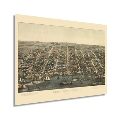
Produced and published by one of the earlier proponents of the birds eye perspective style, Charles Magnus, this stunning depiction shows one of the most iconic areas in the United States in a period of significant growth and transformation. He became well known during the American Civil War for his patriotic prints of Washington and Lincoln, and his work is noted for its use of the highest quality printing processes available. Alexandria was the site of the first casualties of the Civil War, and it remained an important location throughout the conflict. Its location on the western banks of the Potomac River, only six miles south of Washington DC, has contributed to its growth and economy since the early portions of the nineteenth century. The city remained occupied by Union troops for the duration of the Civil War. This stunning depiction shows the city in a period of significant transformation during the middle of the war. Magnus’ artists often used similar styles, and their unique aesthetic immediately transports the viewer back in time, creating an indelible bond between the past and present. Much like most of the region, the city’s economy is largely dependent on the Federal Government and the Department of Defense, though in the latter portion of the nineteenth century, a thriving glass, brewing, and bottling industry spurred growth. This is an authentic piece of American cartographical history that captures a pivotal moment in Alexandria’s rich history as the Civil War continued to wage for two more years.Our museum quality giclee print comes printed with archival ink on premium heavyweight matte paper. This eye-catching vintage map reproduction print makes the perfect gift for anyone that loves history and imagery.
FREE Delivery
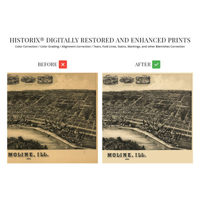
Located on a bluff between the banks of the iconic Mississippi River and Rock River, Moline is the largest city in Rock Island County and one of the cultural hubs of the so-called Quad Cities. This birds-eye perspective published by one of the most prolific American publishers of the style, Henry Wellge, bears a signature style. Wellge was among six cartographers responsible for creating more than half of all American bird’s eye perspectives. This map bears some of his most recognizable flourishes, including bustling industrial activity to highlight economic opportunity. By the late eighteenth century, the city had experienced significant growth spurred by immigrants attracted by work in the thriving mills.Moline got its name from the French term moulin, which translates to mill town. Its proximity to the Mississippi allowed numerous mills to be established, and the region was initially settled in the late eighteenth century by French immigrants. Following the conclusion of the American Civil War, Moline experienced another period of significant growth. Moline is home to the Iconic John Deere agricultural equipment company, and its operations have been among the most important economic drivers of the city. By 1889 Moline was a thoroughly modern American city with electricity, streetcars, and robust municipal services.This depiction’s classic aesthetic immediately transports the viewer back in time, creating an indelible bond between the past and present. This is an authentic piece of American cartographical history that captures one of America’s most iconic small towns in a significant period.Our museum quality giclee print comes printed with archival ink on premium heavyweight matte paper. This eye-catching vintage map reproduction print makes the perfect gift for anyone that loves history and imagery.

FREE Delivery
Produced and published by one of the more prolific birds eye perspective illustrators of the nineteenth century, J.J. Stoner, this stunning depiction of Colorado Springs and the surrounding areas shows the cities in a period of significant growth and transformation. Founded after the Peaks Gold Rush in the late 1850s, the area was being settled by a large influx of English immigrants who established neighborhoods and communities along cultural lines, many of which exist to this day. Now, the second-most populous city in Colorado, the city bears a unique culture and served as the territorial Capital during the state's early years.Birdseye perspectives were widely popular during the nineteenth and twentieth centuries and served as marketing materials to promote prominent civic features, religious and educational institutes, and geographic attractions. The arrival of railroads in 1871 opened access and allowed for a population boom and increased tourism due to the region's proximity to Pikes Peak and the Southern Rocky Mountains. Stoner worked closely with Albert Ruger, whose collection was purchased by the Library of Congress in 1941 and contained some of the most prominent panoramic maps of cities across America. Colorado Springs began annexing the surrounding cities to form a larger municipality in the 1880s and, by the turn of the century, had grown to more than twenty-thousand residents. This is an authentic piece of American cartographical history that immediately transports the viewer back in time, creating an indelible bond and link between the past and present.Our museum quality giclee print comes printed with archival ink on premium heavyweight matte paper. This eye-catching vintage map reproduction print makes the perfect gift for anyone that loves history and imagery.
FREE Delivery
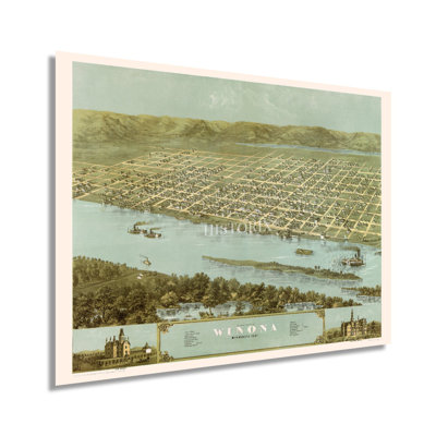
Produced and published by one of the most prolific American mapmakers of the nineteenth century, this depiction of Winona, MN, shows it in a period of transformation in the years following the conclusion of the American Civil War. The city was established in 1851 by European immigrants who laid the initial plans for the town between 1852 and 1853. Its geographic location on the banks of the Mississippi River supported a thriving milling industry spurred on by steamboats transporting goods for export out of the bustling ports in New Orleans. Ruger was a pioneer of the birds-eye perspective style, which was widely popular during the nineteenth century and into the early portions of the twentieth century.In 1859 Polish immigrants began flocking to the city, and by 1900, Polish and the closely related Kashubians comprised nearly eighty percent of Winona’s population. Winona became the home to the second operational railroad in Minnesota following the completion of the Winona and St. Peter Railroad in 1862. This map bears Ruger’s characteristic style, including bustling waterways with artistic insets and flourishes. Birdseye perspectives served as marketing materials to promote cities and towns across the United States and featured prominent civic buildings and industrial features to attract residents and merchants alike.Following a destructive fire in 1862, the city began quarrying the limestone reserves nearby, which resulted in the iconic Sugar Loaf pinnacle, which has become one of the town’s most prominent features. This is an authentic piece of American cartographical history.Our museum quality giclee print comes printed with archival ink on premium heavyweight matte paper. This eye-catching vintage map reproduction print makes the perfect gift for anyone that loves history and imagery.

FREE Delivery
Produced and published by the imprint Hughes & Bailey, this birds-eye perspective illustrates Shelton, Connecticut in a period of significant prosperity during the early twentieth century. Oakley Hoopes Bailey was among the most prolific producers of panoramic maps, and his career spanned more than five decades. Bailey’s images bear a signature style and ornate artistic flourishes that are immediately recognizable and transport the viewer back in time, creating an indelible bond between the past and present. Birdseye perspectives served as marketing materials to promote prominent civic buildings and economic opportunities to entice and attract prospective residents and merchants alike.Originally settled by the English in 1639, Shelton had grown into a manufacturing and milling center by the early portions of the twentieth century facilitated by its proximity to the Housatonic River and the Long Island Sound. The borough was officially incorporated in 1915 and consolidated with the town of Huntington in the same year as this publication to establish the present-day boundaries. Many of the city’s industrial nineteenth-century buildings remain to this day, and revitalization efforts are underway for the historic downtown, including cobblestones sidewalks and significant improvements being made to the area.This is an authentic piece of American cartographical history that illustrates a period of significant transformation across the nation as technological advances and improvements brought towns and cities into the modern era. Shelton was no different and had attracted numerous residents who established neighborhoods and communities, many of which exist to this day.Our museum quality giclee print comes printed with archival ink on premium heavyweight matte paper. This vintage map makes the perfect gift for anyone that loves history and imagery.

FREE Delivery
Produced and published by one of the most prominent birds-eye perspective illustrators of his time, D.D. Morse, this distinguished depiction of San Gabriel shows the city in a period of significant growth and transformation. At this time, the area was primarily agrarian, and extensive vineyards and farms produced a wide variety of fruits and vegetables that were transported to major markets across America. As Los Angeles grew to the city's west, it would eventually be incorporated into the metropolitan area. The city was founded by the Spanish in 1771 with the establishment of the Mission San Gabriel Arcángel by Saint Junipero Serra.During the Spanish and Mexican periods, the area served an essential role in the development of Los Angeles and Californio society, and it is often called the birthplace of the Los Angeles region. Located at the base of the San Gabriel Mountains, the city remains one of the most historic and iconic parts of Los Angeles due to its rich history and enduring legacies. Morse’s depiction of the city bears a unique aesthetic and traditional style that immediately transports the viewer back in time, creating an indelible bond between the past and present. The area’s distinct culture is a blend of Spanish, Mexican, and American influences that can be seen in the iconic architecture. By the 1890s, much of the region was becoming more modern as America was experiencing significant prosperity during the so-called Gilded Age. This is an authentic piece of cartographical history.Our museum quality giclee print comes printed with archival ink on premium heavyweight matte paper. This eye-catching vintage map reproduction print makes the perfect gift for anyone that loves history and imagery.
FREE Delivery
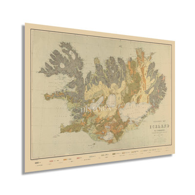
Produced by prominent Icelandic naturalist and geologist Þorvaldur Thoroddsen, this unique map of the Nordic Island shows its wide geological diversity and volcanic features. Iceland is the only portion of the Mid Atlantic Ridge that rises above the Atlantic Ocean and features a central plateau that is home to a volcano field that is nearly constantly erupting. Following the conclusion of the Napoleonic Wars, Denmark and Norway became separate nations, and Iceland remained under Danish rule. Independence movements were growing throughout the nineteenth and early twentieth century. In 1874 Denmark granted Iceland its own constitution with limited home governance. In 1918 Denmark granted Iceland a twenty-five-year period of independence in a personal union with the Dutch. In 1944, Iceland formally became a republic and entered a period of significant economic expansion and prosperity. Thoroddsen studied geology in Copenhagen and was inspired to create this depiction to highlight the natural geological diversity found on the Island. Prior to this publication, the vast wilderness and uninhabited regions of the country had been largely unmapped or documented. Thoroddsen’s depiction is the first to not focus on the populated areas of the country. He would go on to write several books regarding the unique geology of Iceland. This map bears a distinctive aesthetic and classic style that immediately transports the viewer back in time. This rare piece of Icelandic geologic and cartographical history provides an indelible bond between the past and present. Thoroddsen’s map was the earliest depiction to document the nation conclusively.Our museum quality giclee print comes printed with archival ink on premium heavyweight matte paper. This vintage map reproduction print makes the perfect gift for anyone that loves history.
FREE Delivery
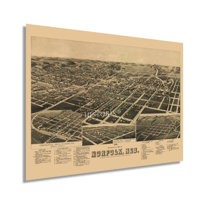
Produced and published by one of the most prolific cartographers of his era, Henry Wellge, this stunning birds eye perspective of Norfolk, Nebraska, shows the town in a period of significant growth and transformation. Wellge, along with five other mapmakers, were responsible for creating more than half of all panoramic maps of the United States during the nineteenth century. Birds eye perspectives were created to attract residents and merchants alike and featured prominent civic buildings, educational and religious institutions, and economic opportunities. They were widely popular from the mid-nineteenth century until the 1920s, when advances in aviation technology and photography became the norm. Their distinctive aesthetic and unique style immediately transport the viewer back in time, creating an indelible bond between the past and present.Norfolk was first established in 1867 by German Lutherans and immigrants from Wisconsin who were looking for farmland that could be established under the Homestead Act. They founded St. Paul’s Lutheran Church, the first in Madison County, which still holds services to this day. By 1889 the city had experienced a significant boom in population due to the expansion of railroads during the latter portions of the nineteenth century. Norfolk would undergo another period of development with the establishment of the Meridian Highway, the first direct North to South automobile route in Nebraska.This is an authentic piece of American cartographical history and captures a transformative period in Norfolk’s rich history as the nation approached the turn of the twentieth century and enjoyed significant prosperity.Our museum quality giclee print comes printed with archival ink on premium heavyweight matte paper. This eye-catching vintage map reproduction makes the perfect gift for anyone that loves history and imagery.
FREE Delivery
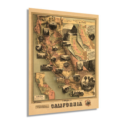
This map was published during a period of significant prosperity in California spurred by thriving ports, profitable mining operations, and vast agricultural production. The completion of the first transcontinental railroad in 1869 expanded access and caused another population boom as immigrants, and other Americans flocked to the region. As part of the Compromise of 1850, California became a free state and was admitted into the Union. During the American Civil War, California shipped gold east in support of Union troops though no military regiments engaged in combat during the conflict. San Francisco and Los Angeles were growing rapidly as their international ports exported numerous goods to thriving markets globally while importing exotic goods from Asia and South America.The Gold Rush during the middle portions of the nineteenth century had shaped the cultural and political landscape throughout the State and drawn eager immigrants from China and Japan, which established numerous communities along cultural lines, many of which exist to this day. This distinctive map bears a unique aesthetic and contains twenty vignettes that serve to promote the State's numerous natural features. Little is known of this map's illustrator, though Johnstone did also produce a climatic map of California published in the same year.Because this map was not produced for geographic reference, it served to attract residents and merchants alike, and it remains an important part of American cartographical history. The distinctive aesthetic immediately transports the viewer back in time, creating a remarkably indelible bond between the past and present.Our museum quality giclee print comes printed with archival ink on premium heavyweight matte paper. This eye-catching vintage map reproduction print makes the perfect gift for anyone that loves history and imagery.

FREE Delivery
Produced and published by one of the most prolific cartographers of his time, Lucien Burleigh, this depiction of the iconic upstate New York town of Kingston bears a unique style and aesthetic that is immediately recognizable. Burleigh’s work is included in the Smithsonian American Art Museum as well as the Boston Public Library archives. Panoramic maps were widely popular during the late nineteenth and early twentieth centuries and served as marketing materials to attract residents and merchants alike. They featured prominent civic and economic features that drew immigrants from across America and Western Europe. The ornate flourishes and attention to detail make these authentic pieces of American cartographical history that link the viewer to the past.Located on the western banks of the Hudson River, Kingston’s rich history dates back to the Colonial era, and it was the first State Capital of New York. The geographic location made it a transportation hub for coal mined in Pennsylvania that traveled down the river to markets in New York City, some ninety-one miles to the South. The city was burned by British Troops following the Battles of Saratoga. This depiction shows Kingston in a period of significant prosperity in the decade following the American Civil War.Manufacturing and shipping had spurred the local economy, and by 1875 numerous industries were thriving. The city is home to three distinct historically recognized neighborhoods known for their architecture and regional significance. This is an authentic piece of American cartographical history with a striking appearance.Our museum quality giclee print comes printed with archival ink on premium heavyweight matte paper. This eye-catching vintage map reproduction print makes the perfect gift for anyone that loves history and imagery.

FREE Delivery
Produced and published by one of the early pioneers of birds eye perspectives, Albert Ruger, this depiction of Jackson, Michigan, shows the city in a period of significant growth and transformation. Founded in 1829, the city is the seat of Jackson County and was named after President Andrew Jackson. Some forty miles west of Ann Arbor, Jackson was an early manufacturer of automobiles and had long been one of Michigan's manufacturing hubs. The city enjoyed a robust transportation infrastructure in the nineteenth century which spurred economic prosperity and attracted immigrants from across Europe who established neighborhoods and communities along cultural lines, many of which exist to this day. Birds eye perspectives were produced as marketing materials to promote civic buildings, religious, educational, and cultural institutions, as well as other economic and geographic features to attract residents and merchants alike. They bear a unique aesthetic and distinctive style that is immediately recognizable and transports the viewer back in time, creating an indelible bond between the past and present. The latter portion of the nineteenth century saw the completion of numerous railroads in the area and allowed for a thriving trade industry to expand.By 1881 Michigan had experienced a considerable influx of residents from America and Europe and developed a distinct culture that was shifting from agriculture to manufacturing as the nation began the so-called Gilded Age. This is an authentic piece of American cartographical history that captures a snapshot of one of the most iconic regions in the country.Our museum quality giclee print comes printed with archival ink on premium heavyweight matte paper. This eye-catching vintage map reproduction print makes the perfect gift for anyone that loves history and imagery.
FREE Delivery
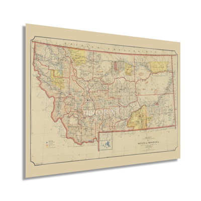
Published only eight years after Montana achieved statehood, this depiction of the iconic region shows it in a period of significant growth, transformation, and prosperity. The Homestead Act of 1862 offered free land to any settler who could establish farms or ranches on up to 160 acres. By the 1880s, the state capital, Helena, had more millionaires than any other American city. The Desert Land Act of 1877 further increased settlement throughout the state as eager immigrants could get up to 640 acres of land for twenty-five cents per acre. This attracted scores of cattle and sheep ranchers, which would become one of the most prominent economic drivers for Montana for the following century.As the nation neared the turn of the century, the establishment of a complete railroad system was almost complete, and this expansion of access and ease of transportation allowed more immigrants to reach the remote state to start small communities based around agricultural exports. Montana did not see settlement begin until the 1850s and remains one of the most sparsely populated regions in the United States. The region was first officially recognized as the eastern portion of the Oregon Territory, which was established in 1848. One of the most notable natural spaces in the United States, Yellowstone National Park, was created in 1872 and draws thousands of tourists annually. This map bears a distinctive aesthetic and classic style that immediately transports the viewer back in time, creating an indelible bond between the past and present.Our museum quality giclee print comes printed with archival ink on premium heavyweight matte paper. This eye-catching vintage map reproduction print makes the perfect gift for anyone that loves history and imagery.
FREE Delivery
Published in the same year as the Founding Fathers signed the Declaration of Independence, this early depiction of Philadelphia is a historically significant piece of early American cartographic history. Europeans began settling the region in the early seventeenth century, with Dutch colonies being established on the banks of the Delaware River. These initial settlements were followed by immigrants from Sweden, Finland, and England who would develop a peaceful relationship with surrounding indigenous peoples, resulting in Philadelphia's rapid growth and prosperity through the following centuries. By the time of this publication, it was the most influential American city. Both its political, cultural, and economic significance as well as its geographic location made it the center for American Revolutionary forces both during and leading up to the Revolutionary War. The city was the site of several battles during the conflict, and British General Howe occupied the city in 1777. By the 1750s, Philadelphia had surpassed Boston to become the largest city with a thriving port that exported goods back to England. Philadelphia was the United States capital from 1790 to 1800 as the District of Columbia was under construction. Benjamin Easburn was a noted surveyor of the time, and this map's minimal aesthetic and classic style distinguishes it from more ornate works of the time. The late eighteenth century was perhaps the most formative period for what would become the United States as it gained independence from Colonial British rule and embarked on a bold path of democratic governance and increased prosperity.Our museum quality giclee print comes printed with archival ink on premium heavyweight matte paper. This eye-catching vintage map reproduction print makes the perfect gift for anyone that loves history and imagery.
FREE Delivery
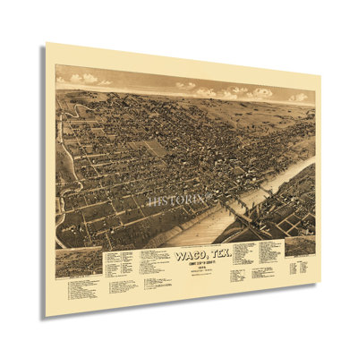
Produced and published by one of the most prolific lithographers and cartographers go the nineteenth century, Henry Wellge, this birds-eye perspective of Waco depicts the iconic city in a period of significant transformation. Wellge is among five American mapmakers responsible for more than half of all panoramic views produced. These illustrations were widely popular from the middle of the 1800s until advances in aviation and photography became the norm. These maps bear a distinctive style and unique aesthetic which is immediately recognizable. They were used to promote prominent civic features, notable geographical assets and attract residents and merchants alike.Baylor University merged with the Waco University in 1866 and shaped the city’s cultural and political growth for the next century. By the latter portion of the nineteenth century, Waco was an important agricultural center for Texas and had become known as a leading producer of cotton for export to major markets in the Northeast and Europe. This illustration includes the cities notable suspension bridge over the Brazos River, which was completed in1870. The bridge expanded the local economy significantly and spurred growth in the downtown area.Waco was settled by European immigrants starting in the 1820s and had grown to more than fifteen thousand residents by the 1880s. This growth was primarily spurred by the installation of extensive rail lines in the region. This is an authentic piece of American cartographical history that transports the viewer back in time, creating an indelible bond between the past and present.Our museum quality giclee print comes printed with archival ink on premium heavyweight matte paper. This eye-catching vintage map reproduction print makes the perfect gift for anyone that loves history and imagery.

2 Sizes
" 1981 Map Of The Appalachian Trail "
By HISTORIC PRINTS
24" H x 36" W x 0.01" D
Rated 5 out of 5 stars.2 total votes
FREE Delivery
Stretching from Springer Mountain in Georgia to Mount Katahdin in Maine, the Appalachian Trail is one of the most iconic and famous trails in North America. Over two thousand miles along, the trail brings more than three million visitors annually. Thru-hiking the trail has become an increasingly popular attraction, with over three thousand hikers a year attempting to complete the entire journey on foot. The concept for the trail was conceived by Benton MacKaye, a forester who believed in preserving the natural elements found in the Eastern United States and allowing urban dwellers a chance to enjoy unspoiled nature.First conceived of in 1921 and started in 1923 the entire project took nearly fifteen years to finish. The trail features some of the most iconic natural imagery in America and is traverses fourteen states. A thru-hike can take anywhere from five to seven months and was first completed in 1968. The trail is maintained by the Appalachian Trail Conservancy, which keeps accurate maps and information available for tourists and hikers. The most isolated portion of the trail is the last section of the Maine portion and is known as the “Hundred Mile Wilderness.” Maine also requires hikers to cross the Kennebec River by boat, the only such crossing.This authentic piece of the trail’s history illustrates the comprehensive route in comprehensive detail. Its distinguished aesthetic is characteristic of the Appalachian Trail Project Office productions based in Harpers Ferry, West Virginia, and features a signature minimal style.Our museum quality giclee print comes printed with archival ink on premium heavyweight matte paper. This eye-catching vintage map reproduction print makes the perfect gift for anyone that loves history and imagery.
Looks great with the frame I purchased.. Joseph. Palm City, FL. Sat Jul 27 2024